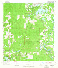
1954 Map of Nobleton
USGS Topo · Published 1966About this map
The Withlacoochee River forms a winding natural boundary for this Central Florida landscape during the mid-1950s, defining the convergence of Citrus, Hernando, and Sumter counties. The Atlantic Coast Line railroad runs parallel to the river, connecting small settlements like Nobleton, Istachatta, and Pineola. This period reveals an active industrial footprint characterized by numerous extractive sites, including the Story Mine, Sixteen Mine, and Ten Cent Mine, alongside various unnamed quarries and sand pits.
Find a feature on this map
38 named features on this map. Tap any name to fly to it.
Don’t see what you’re looking for? This feature index may not catch every label — zoom into the map to look around manually.
Map Details
Editions of this 1954 Nobleton Map
3 editions found
Other maps of this area

1893 · Panasoffkee
USGS Topo · 1:62,500

1895 · Tsala Apopka
USGS Topo · 1:62,500

1895 · Panasoffkee
USGS Topo · 1:62,500

1954 · Lecanto
USGS Topo · 1:24,000

1954 · Brooksville NW
USGS Topo · 1:24,000

1954 · Nobleton
USGS Topo · 1:24,000

1954 · Brooksville
USGS Topo · 1:24,000

1954 · Inverness
USGS Topo · 1:24,000

1954 · Brooksville SE
USGS Topo · 1:24,000

1954 · Inverness
USGS Topo · 1:62,500