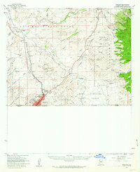
1958 Map of Nogales
USGS Topo · Published 1963About this map
The Southern Pacific and an Old Railroad corridor trace the movement of people and industry along the Santa Cruz River in this late-1950s survey of the border region. The landscape is defined by massive private land holdings and colonial-era legacies, including the Baca Float No 3 and the San Jose De Sonoita Grant. While Nogales serves as the primary urban center with its Nogales International Airport and the Our Lady of Lourdes Academy, the surrounding foothills of the Patagonia Mountains are dense with mineral extraction history. Local prospectors and historians can identify dozens of named operations such as the Three R Mine, Flux Mine, and Robert E Lee Mine. This edition also preserves the location of the Calabasas (Site) and rural landmarks like the Santa Cruz Sch and Yerba Buena Ranch.
Find a feature on this map
93 named features on this map. Tap any name to fly to it.
Don’t see what you’re looking for? This feature index may not catch every label — zoom into the map to look around manually.
Map Details
Editions of this 1958 Nogales Map
3 editions found
Other maps of this area

1904 · Patagonia
USGS Topo · 1:125,000

1905 · Patagonia
USGS Topo · 1:125,000

1905 · Nogales
USGS Topo · 1:125,000

1920 · Arivaca
USGS Topo · 1:125,000

1921 · Old Glory
USGS Topo · 1:125,000

1922 · Agus Caliente
USGS Topo · 1:62,500

1932 · Lochiel
USGS Topo · 1:62,500

1932 · Elgin
USGS Topo · 1:62,500

1933 · Calabasas
USGS Topo · 1:62,500

1939 · Tubac
USGS Topo · 1:62,500