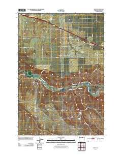
2011 Map of Nolin
USGS Topo · Published 2011About this map
The Umatilla River carves a central path through this Umatilla County landscape, serving as the primary corridor for both agriculture and transport. Near the river's bend, the settlement of Nolin is a focal point for local history, marked by the nearby Nolin Cemetery. The area's water management is evidenced by the Slusher Canal, which parallels the river as it winds through the valley. To the east, the small community of Yoakum sits near the mouth of Mud Spring Canyon.
Find a feature on this map
31 named features on this map. Tap any name to fly to it.
Don’t see what you’re looking for? This feature index may not catch every label — zoom into the map to look around manually.
Map Details
Editions of this 2011 Nolin Map
This is the sole edition of this map. No revisions or reprints were ever made.
Other maps of this area

1908 · Umatilla
USGS Topo · 1:125,000

1935 · Pendleton
USGS Topo · 1:125,000

1953 · Pendleton
USGS Topo · 1:250,000

1956 · Pendleton
USGS Topo · 1:250,000

1962 · Stanfield
USGS Topo · 1:24,000

1962 · Stanfield SE
USGS Topo · 1:24,000

1966 · Holdman
USGS Topo · 1:24,000
1966 · Barnhart
USGS Topo · 1:24,000
1966 · Coombs Canyon
USGS Topo · 1:24,000
1968 · Echo SE
USGS Topo · 1:24,000