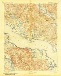
1898 Map of Nomini
USGS Topo · Published 1907About this map
The Wicomico River and Potomac River dominate this coastal landscape, illustrating the critical role of water transport in Southern Maryland and Northern Virginia before the rise of modern highways. This survey highlights a network of commercial landings and wharves, such as Reeder Wharf on the Patuxent River and Nomini Landing on Nomini Bay, which served as the primary hubs for agricultural trade. Inland, the Washington and Potomac R. R. and the Pope Creek Branch P. B. & W. R. R. signal the shift toward rail-dependent logistics in towns like Mechanicsville and Charlotte Hall. The map reveals a densely named shorefront where features like Ludlow Ferry and Nomini Ferry provided essential cross-river connections. This detail is particularly valuable for tracing local genealogy, as it preserves the exact locations of family-named landings and small settlements such as Newburg, Morganza, and the county seat at Leonardtown.
Find a feature on this map
217 named features on this map. Tap any name to fly to it.
Don’t see what you’re looking for? This feature index may not catch every label — zoom into the map to look around manually.
Map Details
Editions of this 1898 Nomini Map
5 editions found

Other maps of this area

1889 · Fredericksburg
USGS Topo · 1:125,000

1890 · Mt. Vernon
USGS Topo · 1:125,000

1891 · Mt. Vernon
USGS Topo · 1:125,000

1892 · Leonardtown
USGS Topo · 1:62,500

1892 · Fredericksburg
USGS Topo · 1:125,000

1892 · Drum Point
USGS Topo · 1:62,500

1892 · Prince Frederick
USGS Topo · 1:62,500

1892 · Brandywine
USGS Topo · 1:62,500

1892 · Piney Point
USGS Topo · 1:62,500

1892 · Montross
USGS Topo · 1:62,500
Featured Places
- Lexington Park, MD
- California, Lexington Park
- Wildewood, Lexington Park
- Colonial Beach, VA
- Golden Beach, MD