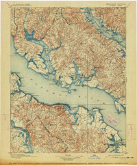
1898 Map of Nomini
USGS Topo · Published 1914About this map
The Potomac River dominates this late-nineteenth-century landscape, serving as a massive nautical corridor between the Southern Maryland and Northern Neck Virginia shorelines. At the river's narrowest point in this area, the Popes Creek Branch P.B.& W. R.R. terminates at Pope Creek Ldg., marking a critical transshipment point for agricultural goods and passengers. The map reveals an economy deeply tied to the water, evidenced by a dense network of landings such as Stone Wharf, Lancaster Wharf, and Howard Wharf lining the many inlets of Saint Clement Bay and the Wicomico River. On the Virginia side, the prominent resort character of Colonial Beach contrasts with the inland agricultural centers of Montross and Hague. For genealogists, the survey preserves the exact placement of early settlements like Charlotte Hall and Mechanicsville, alongside critical navigational aids like the Piney Pt. L.H. and the crossing at Nomini Ferry.
Find a feature on this map
216 named features on this map. Tap any name to fly to it.
Don’t see what you’re looking for? This feature index may not catch every label — zoom into the map to look around manually.
Map Details
Editions of this 1898 Nomini Map
5 editions found

Other maps of this area

1889 · Fredericksburg
USGS Topo · 1:125,000

1890 · Mt. Vernon
USGS Topo · 1:125,000

1891 · Mt. Vernon
USGS Topo · 1:125,000

1892 · Leonardtown
USGS Topo · 1:62,500

1892 · Fredericksburg
USGS Topo · 1:125,000

1892 · Drum Point
USGS Topo · 1:62,500

1892 · Prince Frederick
USGS Topo · 1:62,500

1892 · Brandywine
USGS Topo · 1:62,500

1892 · Piney Point
USGS Topo · 1:62,500

1892 · Montross
USGS Topo · 1:62,500
Featured Places
- Lexington Park, MD
- California, Lexington Park
- Wildewood, Lexington Park
- Colonial Beach, VA
- Golden Beach, MD