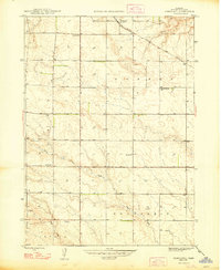
1948 Map of Nonpareil
USGS Topo · Published 1948About this map
The Chicago Burlington and Quincy railroad cuts diagonally across this corner of Box Butte County, marking a vital transit corridor through the High Plains shortly after World War II. The landscape is defined by the headwaters of North Branch Point Rocks Creek and Rocks Creek, where the terrain begins to ripple with the drainage patterns of the western panhandle.
Find a feature on this map
11 named features on this map. Tap any name to fly to it.
Don’t see what you’re looking for? This feature index may not catch every label — zoom into the map to look around manually.
Map Details
Editions of this 1948 Nonpareil Map
2 editions found
Other maps of this area

1946 · Nonpareil
USGS Topo · 1:24,000

1946 · Box Butte Reservoir West
USGS Topo · 1:24,000

1948 · Box Butte Reservoir West
USGS Topo · 1:24,000

1948 · Hemingford
USGS Topo · 1:24,000

1948 · Hemingford 4 NE
USGS Topo · 1:24,000

1948 · Hemingford 4 NW
USGS Topo · 1:24,000

1948 · Nonpareil
USGS Topo · 1:24,000

1948 · Box Butte Reservoir East
USGS Topo · 1:24,000

1951 · Marsland
USGS Topo · 1:62,500

1951 · Kilpatrick Lake
USGS Topo · 1:62,500