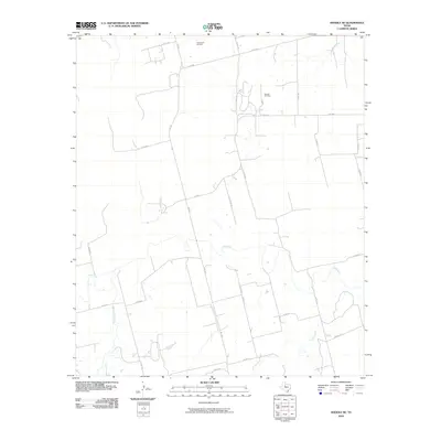
2010 Map of Noodle NE
USGS Topo · Published 2010About this map
Bartlett Oil Field and Farnsworth Oil Field define the economic landscape of this portion of Jones County during the early 21st century. The terrain is structured by a network of farm-to-market and county roads, including FM 126 and FM 2746, which link isolated homesteads and industrial sites. Significant waterways such as the Clear Fork and its tributaries, Sweetwater Creek and Noodle Creek, meander through the rural acreage, indicating the natural drainage patterns that have historically dictated land use and ranching boundaries. The presence of Golf Course Rd and Ranch Rd suggests a mix of traditional agricultural heritage and more modern land developments in this pocket of West Texas.
Find a feature on this map
28 named features on this map. Tap any name to fly to it.
Don’t see what you’re looking for? This feature index may not catch every label — zoom into the map to look around manually.
Map Details
Editions of this 2010 Noodle NE Map
This is the sole edition of this map. No revisions or reprints were ever made.
Other maps of this area

1891 · Anson
USGS Topo · 1:125,000

1893 · Roby
USGS Topo · 1:125,000

1893 · Anson
USGS Topo · 1:125,000

1954 · Big Spring
USGS Topo · 1:250,000

1954 · Abilene
USGS Topo · 1:250,000

1957 · Hawley
USGS Topo · 1:62,500

1957 · Noodle
USGS Topo · 1:62,500

1958 · Big Spring
USGS Topo · 1:250,000

1958 · Abilene
USGS Topo · 1:250,000
1965 · Neinda
USGS Topo · 1:24,000