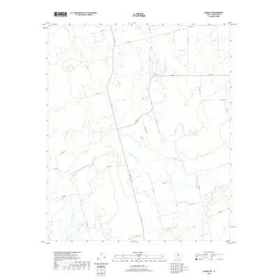
2019 Map of Noodle NE
USGS Topo · Published 2019About this map
The Clear Fork Brazos River winds through this section of Jones County, carving a serpentine path across the landscape and serving as a primary drainage point for several local tributaries. Significant water features including Thompson Cr in the north and the confluence of Noodle Cr and Sweetwater Cr in the south define the drainage patterns of this rural ranching region. The transportation network is built upon a grid of county roads and farm-to-market routes like Fm 126 and Fm 2746, which facilitate movement between scattered homesteads and larger regional centers. A phonetic curiosity is found near the center of the map with the uniquely spelled Golf Corse Rd, while several routes designated simply as Ranch Rd reflect the enduring agricultural character of the West Texas plains.
Find a feature on this map
27 named features on this map. Tap any name to fly to it.
Don’t see what you’re looking for? This feature index may not catch every label — zoom into the map to look around manually.
Map Details
Editions of this 2019 Noodle NE Map
This is the sole edition of this map. No revisions or reprints were ever made.
Other maps of this area
1891 · Anson
USGS Topo · 1:125,000
1893 · Roby
USGS Topo · 1:125,000
1893 · Anson
USGS Topo · 1:125,000
1954 · Big Spring
USGS Topo · 1:250,000
1954 · Abilene
USGS Topo · 1:250,000
1957 · Hawley
USGS Topo · 1:62,500
1957 · Noodle
USGS Topo · 1:62,500
1958 · Big Spring
USGS Topo · 1:250,000
1958 · Abilene
USGS Topo · 1:250,000
1965 · Neinda
USGS Topo · 1:24,000