
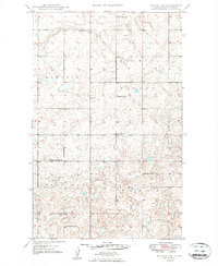
1949 Map of Noonan SW
USGS Topo · Published 1949About this map
Blooming Valley and the Frazier Upland define the rugged topography of Divide County just after the war. This rural landscape is heavily dotted with small prairie potholes and kettle lakes, characteristic of the glaciated plains. The map reveals a decentralized community structure where education and faith were tied to specific rural districts rather than town centers. One can find the Blooming Prairie Ch in the northern section, serving the surrounding farms. The distribution of neighborhood schools, including Bluffton No 2 Sch, McCullough No 2 Sch, and Highland No 2 Sch, indicates a period when student populations were still high enough to support numerous one-room schoolhouses across the Hawkeye region before the widespread consolidation of the late 20th century.
Find a feature on this map
10 named features on this map. Tap any name to fly to it.
Don’t see what you’re looking for? This feature index may not catch every label — zoom into the map to look around manually.
Map Details
Editions of this 1949 Noonan SW Map
2 editions found
Other maps of this area

1947 · Noonan
USGS Topo · 1:24,000

1948 · Alamo N.E.
USGS Topo · 1:24,000

1948 · Crosby
USGS Topo · 1:24,000

1948 · Crosby SE
USGS Topo · 1:24,000

1949 · Paulson
USGS Topo · 1:24,000

1949 · Noonan SE
USGS Topo · 1:24,000

1949 · Noonan
USGS Topo · 1:24,000

1950 · Crosby
USGS Topo · 1:62,500

1950 · Noonan
USGS Topo · 1:62,500

1953 · Williston
USGS Topo · 1:250,000