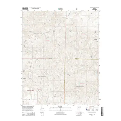
2014 Map of Norfork SE
USGS Topo · Published 2014About this map
The Ozark National Forest dominates this section of the Arkansas Highlands, where the boundary between Baxter and Stone counties follows the ridgelines and creek beds. The landscape is defined by its dramatic verticality, characterized by deep hollows like Birch Minick Hollow and Birmingham Hollow that funnel into a complex drainage system including Leatherwood Cr and Stewart Fork. This 2014 survey documents a region where human presence is sparse and strategically placed along the heights, evidenced by the Push Mountain Lookout Tower atop Push Mtn and the isolated Acklin Cem near Sneeds Cr. Transportation is limited to winding routes such as Push Mountain Rd and State Hwy 14, which navigate the high points like Caroline Gap and Sandy Ridge to avoid the steep descent into Clifty Canyon or the many forks of the Cole Fork.
Find a feature on this map
48 named features on this map. Tap any name to fly to it.
Don’t see what you’re looking for? This feature index may not catch every label — zoom into the map to look around manually.
Map Details
Editions of this 2014 Norfork SE Map
This is the sole edition of this map. No revisions or reprints were ever made.
Other maps of this area
1890 · Mountain Home
USGS Topo · 1:125,000
1891 · Mountain Home
USGS Topo · 1:125,000
1892 · Mountain View
USGS Topo · 1:125,000
1894 · Mountain View
USGS Topo · 1:125,000
1894 · Mountain Home
USGS Topo · 1:125,000
1945 · Harrison
USGS Topo · 1:250,000
1949 · Harrison
USGS Topo · 1:250,000
1954 · Harrison
USGS Topo · 1:250,000
1956 · Russellville
USGS Topo · 1:250,000
1958 · Harrison
USGS Topo · 1:250,000