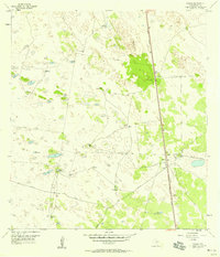
1956 Map of Norias
USGS Topo · Published 1958About this map
Deep within the coastal plains of Kenedy County, the Norias settlement serves as a vital point of habitation along the Missouri Pacific railroad. This 1950s survey reveals a landscape where survival and ranching depend heavily on subterranean water, evidenced by a dense network of family-named water sources such as the Rodeo Artesian Well, Botero Artesian Well, and Lorenzo Artesian Well. The geography is defined by undulating shifting sand dunes 10-15 feet high, which dictate the placement of fences and private ranch roads across the terrain.
Find a feature on this map
22 named features on this map. Tap any name to fly to it.
Don’t see what you’re looking for? This feature index may not catch every label — zoom into the map to look around manually.
Map Details
Editions of this 1956 Norias Map
2 editions found
Other maps of this area

1921 · Tarida Ranch
USGS Topo · 1:62,500

1922 · La Sal Vieja
USGS Topo · 1:62,500

1923 · Armstrong
USGS Topo · 1:62,500

1923 · Saltillo Ranch
USGS Topo · 1:62,500

1953 · Brownsville
USGS Topo · 1:250,000

1956 · Pita Camp
USGS Topo · 1:24,000
1956 · Armstrong
USGS Topo · 1:24,000
1956 · San Pedro Ranch
USGS Topo · 1:24,000

1956 · Julian
USGS Topo · 1:24,000

1956 · Saltillo Well
USGS Topo · 1:24,000