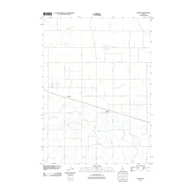
2010 Map of Norland
USGS Topo · Published 2010About this map
Adelaide and Norland anchor this agricultural landscape in Minidoka County, Idaho, where a rigid grid of rural roads defines the high desert territory north of the Snake River. The map illustrates a highly organized irrigation and transport system, characterized by long, straight thoroughfares such as 1500 North Rd and N Meridian. These routes intersect at precise intervals, supporting the region's farming heritage. The influence of water management is visible through the F Main Drain, a critical piece of infrastructure in this arid environment. This 2010 survey reflects the enduring layout of the Minidoka project area, showing the deliberate planning that transformed the sagebrush plains into productive farmland. For genealogists or local historians, the specific road designations like 300 West Rd and 1200 North Rd provide exact spatial context for family landholdings and rural residences.
Find a feature on this map
28 named features on this map. Tap any name to fly to it.
Don’t see what you’re looking for? This feature index may not catch every label — zoom into the map to look around manually.
Map Details
Editions of this 2010 Norland Map
This is the sole edition of this map. No revisions or reprints were ever made.
Other maps of this area

1954 · Pocatello
USGS Topo · 1:250,000

1958 · Pocatello
USGS Topo · 1:250,000

1964 · Burley NE
USGS Topo · 1:24,000

1964 · Rupert NW
USGS Topo · 1:24,000

1964 · Acequia
USGS Topo · 1:24,000

1972 · Shale Butte
USGS Topo · 1:24,000

1972 · Kimama
USGS Topo · 1:24,000

1972 · Community Lake
USGS Topo · 1:24,000

1972 · Max
USGS Topo · 1:24,000
1972 · Norland
USGS Topo · 1:24,000