
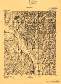
1893 Map of Norman
USGS Topo · Published 1893About this map
Norman and the surrounding prairie of Cleveland County are captured here during the transitional period of the 1890s, shortly after the Land Run of 1889. The Oklahoma Indian Territory Boundary Line follows the meandering course of the Canadian River, serving as a stark political divider on the landscape. To the north, the town of Norman is established along the Atchison Topeka and Santa Fe R. R., while smaller outposts like Denver and Noble dot the rolling terrain.
Find a feature on this map
16 named features on this map. Tap any name to fly to it.
Don’t see what you’re looking for? This feature index may not catch every label — zoom into the map to look around manually.
Map Details
Editions of this 1893 Norman Map
2 editions found
Other maps of this area

1892 · Moore
USGS Topo · 1:62,500

1893 · Oklahoma City
USGS Topo · 1:62,500

1898 · Purcell
USGS Topo · 1:125,000

1898 · Pauls Valley
USGS Topo · 1:125,000

1902 · Pauls Valley
USGS Topo · 1:125,000

1902 · Rush Springs
USGS Topo · 1:125,000

1904 · Chickasha
USGS Topo · 1:125,000

1910 · McComb
USGS Topo · 1:62,500

1925 · Norman NO 2
USGS Topo · 1:24,000

1930 · McLoud
USGS Topo · 1:62,500