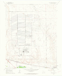
1960 Map of North Avondale
USGS Topo · Published 1963About this map
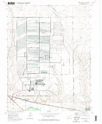
The Pueblo Ordnance Depot dominates this Cold War-era landscape, its massive grid of bunkers and facilities occupying a large Military Reservation Boundary north of the river. This industrial military presence contrasts sharply with the agricultural and rail-oriented settlements to the south, where the town of North Avondale serves as a local hub near the Excelsior Sch. The southern corridor is defined by the heavy transport infrastructure of the Atchison Topeka and Santa Fe and Missouri Pacific railroads, which parallel the Arkansas River. Irrigation infrastructure, vital for high-plains agriculture, is evident in the Colorado Canal, while natural drainage is provided by several intermittent watercourses including Haynes Creek, Chico Creek, and Boone Creek. The small community of Boone sits at the southeastern edge of the map, illustrating the rail-river settlement pattern of Pueblo County.
Find a feature on this map
18 named features on this map. Tap any name to fly to it.
Don’t see what you’re looking for? This feature index may not catch every label — zoom into the map to look around manually.
Map Details
Editions of this 1960 North Avondale Map
5 editions found
Other maps of this area

1891 · Nepesta
USGS Topo · 1:125,000

1893 · Nepesta
USGS Topo · 1:125,000

1904 · Nepesta
USGS Topo · 1:125,000

1954 · Pueblo
USGS Topo · 1:250,000

1957 · Pueblo
USGS Topo · 1:250,000

1958 · Pueblo
USGS Topo · 1:250,000

1959 · Highlands Church
USGS Topo · 1:24,000

1959 · North Avondale NE
USGS Topo · 1:24,000
1960 · Nepesta
USGS Topo · 1:24,000
1960 · Boone Hill
USGS Topo · 1:24,000