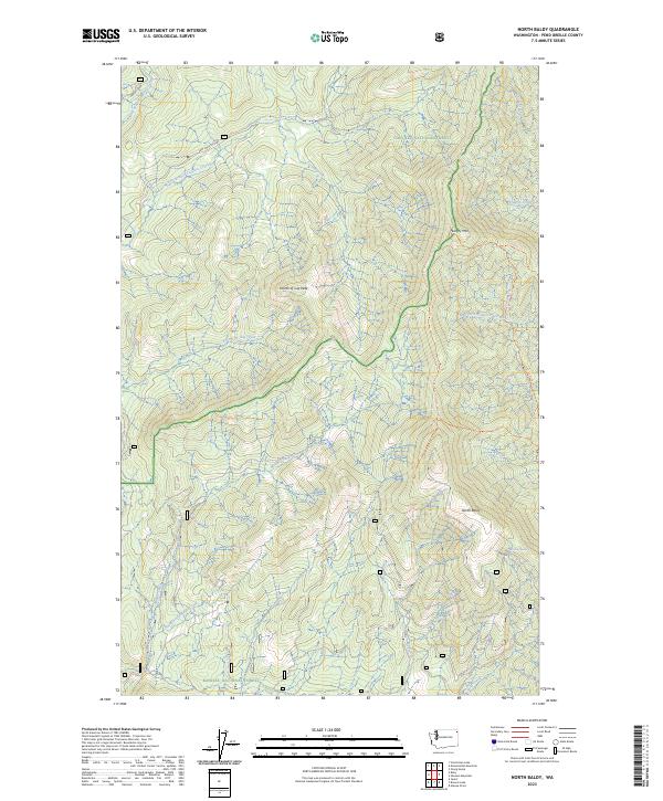
2023 Map of North Baldy
USGS Topo · Published 2023About this map
Colville National Forest and Kaniksu National Forest converge in this high-altitude landscape of Pend Oreille County, defined by prominent summits and an intricate network of drainage headwaters. The terrain is anchored by North Baldy and Hungry Mtn, with the Fourth of July Peak rising as a central landmark. These peaks separate the westward-flowing waters of Middle Branch Le Clerc Creek and East Branch Le Clerc Creek from the eastward-draining Upper West Branch Priest River. The presence of the Stateline Trl and the Kalispell Rock-North Baldy Trl indicates a geography primarily accessed through primitive routes. This high mountain divide serves as a critical watershed, where numerous smaller streams like Fourth of July Creek and Syllids Creek originate from springs such as Grouse Springs.
Find a feature on this map
26 named features on this map. Tap any name to fly to it.
Don’t see what you’re looking for? This feature index may not catch every label — zoom into the map to look around manually.
Map Details
Editions of this 2023 North Baldy Map
This is the sole edition of this map. No revisions or reprints were ever made.
Other maps of this area

1934 · Metaline
USGS Topo · 1:125,000

1936 · Newport
USGS Topo · 1:96,000

1942 · Metaline
USGS Topo · 1:125,000

1942 · Newport
USGS Topo · 1:125,000

1958 · Sandpoint
USGS Topo · 1:250,000

1963 · Sandpoint
USGS Topo · 1:250,000

1967 · Scotchman Lake
USGS Topo · 1:24,000

1967 · Monumental Mtn.
USGS Topo · 1:24,000
1967 · Orwig Hump
USGS Topo · 1:24,000
1967 · North Baldy
USGS Topo · 1:24,000