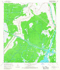
1966 Map of North Bend
USGS Topo · Published 1967About this map
The Gulf Intracoastal Waterway cuts through this portion of St. Mary Parish, providing a window into the industrial and agricultural landscape of the mid-1960s. The settlement of North Bend and the Lottery Field Oil and Gas Field illustrate the region's reliance on both maritime transport and natural resource extraction. The Southern Pacific railroad parallels the historic Bayou Sale, serving as a lifeline for the sugar and oil economies that defined this coastal stretch. Numerous family and local burial grounds, such as North Bend Cem, Midway Cem, and the Shadyside-Fairfax Cem, are scattered along the natural levees, marking the deep ancestral ties of the people living in the marshes. Inland, a complex network of waterways including Heckerson Bayou, Clausen Bayou, and Big Bayou Oaks weave through the wetlands toward Wax Lake, showing a landscape where the boundary between land and water is constantly shifting.
Find a feature on this map
51 named features on this map. Tap any name to fly to it.
Don’t see what you’re looking for? This feature index may not catch every label — zoom into the map to look around manually.
Map Details
Editions of this 1966 North Bend Map
3 editions found
Other maps of this area

1935 · Belle Isle
USGS Topo · 1:31,680

1937 · Bayou Sale
USGS Topo · 1:62,500

1937 · Jeanerette
USGS Topo · 1:62,500

1941 · Belle Isle
USGS Topo · 1:62,500

1945 · New Orleans
USGS Topo · 1:250,000

1948 · Foster
USGS Topo · 1:62,500

1954 · Jeanerette
USGS Topo · 1:62,500

1954 · Belle Isle
USGS Topo · 1:62,500

1957 · Bayou Sale
USGS Topo · 1:62,500

1959 · Foster
USGS Topo · 1:62,500