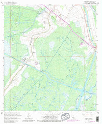
1966 Map of North Bend
USGS Topo · Published 1981About this map
Bayou Teche and the Southern Pacific railroad define the industrial and transit corridor of this St. Mary Parish landscape during the mid-1960s. The region is characterized by a complex network of waterways, including the Intracoastal Waterway and the Atchafalaya Floodway, which facilitated both the movement of goods and the management of the coastal environment. Heavy industrial activity is evident in the Garden City Gas and Oil Field, where numerous pumping stations and canals like the Thorguson Canal crisscross the terrain.
Find a feature on this map
54 named features on this map. Tap any name to fly to it.
Don’t see what you’re looking for? This feature index may not catch every label — zoom into the map to look around manually.
Map Details
Editions of this 1966 North Bend Map
3 editions found
Other maps of this area

1935 · Belle Isle
USGS Topo · 1:31,680

1937 · Bayou Sale
USGS Topo · 1:62,500

1937 · Jeanerette
USGS Topo · 1:62,500

1941 · Belle Isle
USGS Topo · 1:62,500

1945 · New Orleans
USGS Topo · 1:250,000

1948 · Foster
USGS Topo · 1:62,500

1954 · Jeanerette
USGS Topo · 1:62,500

1954 · Belle Isle
USGS Topo · 1:62,500

1957 · Bayou Sale
USGS Topo · 1:62,500

1959 · Foster
USGS Topo · 1:62,500