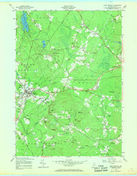
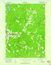
1956 Map of North Berwick
USGS Topo · Published 1969About this map
The Boston and Maine Railroad cuts a prominent diagonal across this Southern Maine landscape, centering on the industrious hub of North Berwick. The town's layout in the mid-1950s reveals a cluster of activity including a High Sch, the Bethel Gospel Mission, and numerous local cemeteries. To the east and south, the terrain transitions into the complex drainage systems of The Heath and Johns Swamp, where the Merriland River and Webhannet River find their headwaters.
Find a feature on this map
80 named features on this map. Tap any name to fly to it.
Don’t see what you’re looking for? This feature index may not catch every label — zoom into the map to look around manually.
Map Details
Editions of this 1956 North Berwick Map
3 editions found

Other maps of this area

1891 · Berwick
USGS Topo · 1:62,500

1891 · Kennebunk
USGS Topo · 1:62,500

1893 · Kennebunk
USGS Topo · 1:62,500

1893 · Dover
USGS Topo · 1:62,500

1893 · Berwick
USGS Topo · 1:62,500

1893 · York
USGS Topo · 1:62,500

1898 · Kennebunk
USGS Topo · 1:62,500

1916 · Dover
USGS Topo · 1:62,500

1918 · Dover
USGS Topo · 1:62,500

1920 · York
USGS Topo · 1:62,500