1956 Map of North Berwick
USGS Topo · Published 1958About this map
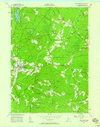
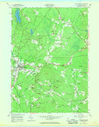
The Boston and Maine Railroad serves as a primary corridor through this portion of York County, connecting the industrial and residential centers of North Berwick and Highpine. The landscape is a mosaic of small crossings and rural gathering points such as Saywards Corner, Parsonage Corner, and Varney Crossing. Cultural landmarks like Zebulon Knight Hall and the South Berwick-Wells Ch reflect the community life of the mid-1950s, while the Sanford Country Club and Sanford Health Camp suggest the area's role as a recreational retreat for nearby residents.
Find a feature on this map
71 named features on this map. Tap any name to fly to it.
Don’t see what you’re looking for? This feature index may not catch every label — zoom into the map to look around manually.
Map Details
Editions of this 1956 North Berwick Map
3 editions found

Other maps of this area

1891 · Berwick
USGS Topo · 1:62,500

1891 · Kennebunk
USGS Topo · 1:62,500

1893 · Kennebunk
USGS Topo · 1:62,500

1893 · Dover
USGS Topo · 1:62,500

1893 · Berwick
USGS Topo · 1:62,500

1893 · York
USGS Topo · 1:62,500

1898 · Kennebunk
USGS Topo · 1:62,500

1916 · Dover
USGS Topo · 1:62,500

1918 · Dover
USGS Topo · 1:62,500

1920 · York
USGS Topo · 1:62,500