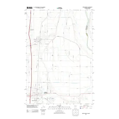
2013 Map of North Branch
USGS Topo · Published 2013About this map
The North Branch and Harris corridor in Chisago County is defined by its agrarian patterns and the proximity to the Saint Croix River at the Wisconsin border. A notable concentration of community burial sites, including the Old Harris Cem, Mission Covenant Cem, and Oak Grove Cem, provides significant data for genealogical research and family history in this portion of eastern Minnesota. The landscape is a mix of small-scale residential developments like Oakwood Court and functional landmarks such as Pinetree Airpark.
Find a feature on this map
80 named features on this map. Tap any name to fly to it.
Don’t see what you’re looking for? This feature index may not catch every label — zoom into the map to look around manually.
Map Details
Editions of this 2013 North Branch Map
This is the sole edition of this map. No revisions or reprints were ever made.
Other maps of this area

1950 · Rush City
USGS Topo · 1:48,000

1953 · Stillwater
USGS Topo · 1:250,000

1955 · Rush City
USGS Topo · 1:62,500

1955 · Forest Lake
USGS Topo · 1:62,500

1955 · Isanti
USGS Topo · 1:62,500

1955 · Stillwater
USGS Topo · 1:250,000

1958 · Stillwater
USGS Topo · 1:250,000

1961 · Cambridge
USGS Topo · 1:62,500

1965 · Stillwater
USGS Topo · 1:250,000
1974 · Stacy
USGS Topo · 1:24,000