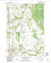
1983 Map of North Branch
USGS Topo · Published 1984About this map
St Croix National Scenic Riverway and the Governor Knowles State Forest define the eastern border of this mid-1980s survey, where the St Croix River separates Minnesota from Wisconsin. The interior is a mixture of agricultural land and managed wetlands, including Pine Island and several watercourses like Goose Creek and Hay Creek. The Burlington Northern railroad corridor serves as the primary north-south axis, connecting the communities of Harris and North Branch. Local genealogy is well-documented through numerous sites such as Oak Grove Cem, Mission Covenant Cem, and Trinity Ch with its adjacent Trinity Cem. The landscape reflects a transition from river-valley wilderness to established township grids, featuring various gravel pits and specialized facilities like the local Landing Strip and High Sch.
Find a feature on this map
43 named features on this map. Tap any name to fly to it.
Don’t see what you’re looking for? This feature index may not catch every label — zoom into the map to look around manually.
Map Details
Editions of this 1983 North Branch Map
This is the sole edition of this map. No revisions or reprints were ever made.
Other maps of this area

1950 · Rush City
USGS Topo · 1:48,000

1953 · Stillwater
USGS Topo · 1:250,000

1955 · Rush City
USGS Topo · 1:62,500

1955 · Forest Lake
USGS Topo · 1:62,500

1955 · Isanti
USGS Topo · 1:62,500

1955 · Stillwater
USGS Topo · 1:250,000

1958 · Stillwater
USGS Topo · 1:250,000

1961 · Cambridge
USGS Topo · 1:62,500

1965 · Stillwater
USGS Topo · 1:250,000
1974 · Stacy
USGS Topo · 1:24,000
Featured Places
- North Branch, MN
- Harris, MN
- Peaceful Valley Mobile Home Park, North Branch
- Sunrise Township, MN
- Sterling, WI