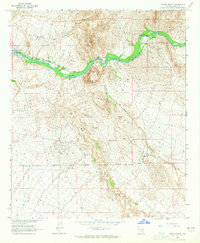
1964 Map of North Butte
USGS Topo · Published 1965About this map
The Gila River corridor dominates this 1964 survey of Pinal County, Arizona, where water management and mineral processing define the desert landscape. The Southern Pacific railroad follows the river's winding course, serving small outposts like Price and Cochran. Evidence of historical industry is found near the river at the Coke Ovens, while the Ashurst-Hayden Dam downstream signifies the mid-century transformation of local water resources. The terrain is marked by prominent igneous features, most notably North Butte and South Butte, which rise sharply above the river canyon. Away from the water, the land is etched by seasonal drainages such as Box O Wash, Donnelly Wash, and Martinez Canyon, illustrating the arid conditions surrounding the isolated Donnelly Ranch. This survey captures a moment when the regional economy remained tied to the established rail lines and the control of the Gila's flow.
Find a feature on this map
17 named features on this map. Tap any name to fly to it.
Don’t see what you’re looking for? This feature index may not catch every label — zoom into the map to look around manually.
Map Details
Editions of this 1964 North Butte Map
3 editions found
Other maps of this area

1900 · Florence
USGS Topo · 1:125,000

1902 · Florence
USGS Topo · 1:125,000

1922 · Red Rock No 2
USGS Topo · 1:48,000

1934 · Newman Peak
USGS Topo · 1:125,000

1954 · Mesa
USGS Topo · 1:250,000

1956 · Tucson
USGS Topo · 1:250,000

1957 · Mesa
USGS Topo · 1:250,000

1958 · Mesa
USGS Topo · 1:250,000

1958 · Tucson
USGS Topo · 1:250,000

1959 · Tucson
USGS Topo · 1:250,000