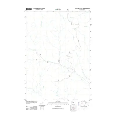
2012 Map of North Fork Pickett Creek
USGS Topo · Published 2012About this map
Pickett Cr and its tributaries define the hydrological character of this Park County landscape. As of 2012, the drainage network across this region is extensive, with the N Fork Pickett Cr flowing through the central portion of the quadrangle. To the south, Big Piney Reservoir serves as a significant water catchment near Piney Cr, while the northern reaches are marked by the branching headwaters of Meeteetse Cr and the eastern and middle forks of Rock Creek. The map reveals a high-elevation terrain where the economy and movement are dictated by these watercourses and the relief of Rose Cr and Little Rose Cr. This area of Wyoming remains sparsely settled, with the land primarily organized around these natural drainages and the occasional crossing of Rawhide Cr.
Find a feature on this map
10 named features on this map. Tap any name to fly to it.
Don’t see what you’re looking for? This feature index may not catch every label — zoom into the map to look around manually.
Map Details
Editions of this 2012 North Fork Pickett Creek Map
This is the sole edition of this map. No revisions or reprints were ever made.
Other maps of this area

1955 · Cody
USGS Topo · 1:250,000

1957 · Wapiti
USGS Topo · 1:62,500

1957 · Devils Tooth
USGS Topo · 1:62,500

1957 · Irish Rock
USGS Topo · 1:62,500

1957 · Sunshine Reservoir
USGS Topo · 1:62,500

1958 · Cody
USGS Topo · 1:250,000

1962 · Cody
USGS Topo · 1:250,000

1980 · Carter Mountain
USGS Topo · 1:100,000
1987 · Devils Tooth
USGS Topo · 1:24,000
1987 · Pitchfork
USGS Topo · 1:24,000