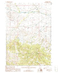
1987 Map of Pitchfork
USGS Topo · Published 1988About this map
Shoshone National Forest dominates the southern half of this landscape, where high-country drainages like Pappapau Creek and Gwinn Fork Dick Creek flow through the timbered foothills of the Absaroka Range. Along the northern edge, the Greybull River serves as the primary artery for agricultural and industrial activity. The presence of the Pitchfork Ditch and Sunshine Supply Ditch illustrates the vital role of water management in supporting the local ranching economy. Near the settlement of Pitchfork, the Four Bear Oil Field marks a pocket of mineral extraction, with a network of unimproved roads and pipelines threading through the terrain. The Timber Creek Ranger Station stands as a lonely outpost at the forest boundary, monitoring the transition from the irrigated river valley to the wilder reaches of the national forest.
Find a feature on this map
25 named features on this map. Tap any name to fly to it.
Don’t see what you’re looking for? This feature index may not catch every label — zoom into the map to look around manually.
Map Details
Editions of this 1987 Pitchfork Map
This is the sole edition of this map. No revisions or reprints were ever made.
Other maps of this area

1904 · Kirwin
USGS Topo · 1:125,000

1906 · Kirwin
USGS Topo · 1:125,000

1955 · Cody
USGS Topo · 1:250,000

1955 · Thermopolis
USGS Topo · 1:250,000

1957 · Irish Rock
USGS Topo · 1:62,500

1957 · Sunshine Reservoir
USGS Topo · 1:62,500

1958 · Cody
USGS Topo · 1:250,000

1958 · Thermopolis
USGS Topo · 1:250,000

1962 · Thermopolis
USGS Topo · 1:250,000

1962 · Cody
USGS Topo · 1:250,000