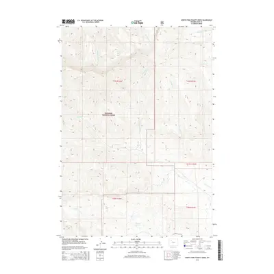
2015 Map of North Fork Pickett Creek
USGS Topo · Published 2015About this map
Shoshone National Forest lands dominate this high-altitude landscape in Park County, where the eastern front of the Absaroka Range transitions into the Bighorn Basin. The complex drainage network is defined by the N Fork Pickett Cr and the main stem of Pickett Cr, which flow eastward toward the arid plains. Higher elevations are marked by glacial features like Martin Lake, while the southern portion of the map shows human efforts to manage water in this dry environment at the Big Piney Reservoir. Evidence of the region’s energy economy is found along the southern border with the presence of Four Bear Oil Field Rd. The map also traces the headwaters of Meeteetse Cr and several forks of Rock Creek, including Middle Fork Rock Cr and E Fork Rock Cr, illustrating the rugged, dissected topography that characterizes this portion of northwestern Wyoming.
Find a feature on this map
18 named features on this map. Tap any name to fly to it.
Don’t see what you’re looking for? This feature index may not catch every label — zoom into the map to look around manually.
Map Details
Editions of this 2015 North Fork Pickett Creek Map
This is the sole edition of this map. No revisions or reprints were ever made.
Other maps of this area

1955 · Cody
USGS Topo · 1:250,000

1957 · Wapiti
USGS Topo · 1:62,500

1957 · Devils Tooth
USGS Topo · 1:62,500

1957 · Irish Rock
USGS Topo · 1:62,500

1957 · Sunshine Reservoir
USGS Topo · 1:62,500

1958 · Cody
USGS Topo · 1:250,000

1962 · Cody
USGS Topo · 1:250,000

1980 · Carter Mountain
USGS Topo · 1:100,000
1987 · Devils Tooth
USGS Topo · 1:24,000
1987 · Pitchfork
USGS Topo · 1:24,000