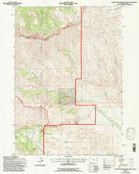
1991 Map of North Fork Pickett Creek
USGS Topo · Published 1997About this map
Carter Mountain dominates this high-elevation landscape within the Shoshone National Forest, where the transition from managed forest lands to the Washakie Wilderness is marked by a sharp administrative boundary. The drainage patterns on this 1991 survey reflect a complex network of alpine headwaters, including the North Fork Pickett Creek and Meeteetse Creek, which carve through the steep eastern slopes of the range. The boundary between the Wapiti Ranger District and Greybull Ranger District follows the high ridgelines, illustrating how natural topographic features often dictate forest management borders. In the lower elevations to the east, the land is divided into numerous numbered tracts and lots, such as Tract 37 and Lot 42, suggesting historical land partitions adjacent to Aldrich Basin. Evidence of resource exploration appears near the head of Rawhide Creek, noted by a lone Drill Hole alongside primitive 4wd routes.
Find a feature on this map
35 named features on this map. Tap any name to fly to it.
Don’t see what you’re looking for? This feature index may not catch every label — zoom into the map to look around manually.
Map Details
Editions of this 1991 North Fork Pickett Creek Map
This is the sole edition of this map. No revisions or reprints were ever made.
Other maps of this area

1955 · Cody
USGS Topo · 1:250,000

1957 · Wapiti
USGS Topo · 1:62,500

1957 · Devils Tooth
USGS Topo · 1:62,500

1957 · Irish Rock
USGS Topo · 1:62,500

1957 · Sunshine Reservoir
USGS Topo · 1:62,500

1958 · Cody
USGS Topo · 1:250,000

1962 · Cody
USGS Topo · 1:250,000

1980 · Carter Mountain
USGS Topo · 1:100,000
1987 · Devils Tooth
USGS Topo · 1:24,000
1987 · Pitchfork
USGS Topo · 1:24,000