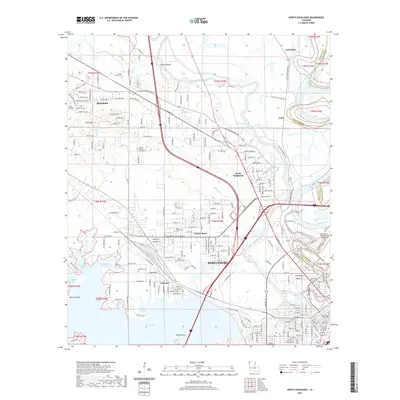
2020 Map of North Highlands
USGS Topo · Published 2020About this map
Shreveport expands northward along the banks of the Red River and the complex waterways of Twelvemile Bayou in this recent survey. The landscape is defined by the transition from dense urban infrastructure near the Caddo Parish Courthouse and Shreveport Downtown Airport to the established residential neighborhoods of Cooper Road, North Highlands, and Lakeview. Family history is deeply rooted across the quadrangle, evident in the numerous burial grounds ranging from the expansive Oakland Cem to the smaller Shows Family Cem and Walker Hill Cem further north. The northwestern corridor follows the Kansas City Southern rail line toward Blanchard, passing the elevated Albany Bluffs. The map also details the varied aquatic environments of Cross Lake, including several named inlets such as Ben Roberts Pocket and Hicks Pocket, providing a clear look at the intersection of municipal growth and the natural bayou system.
Find a feature on this map
55 named features on this map. Tap any name to fly to it.
Don’t see what you’re looking for? This feature index may not catch every label — zoom into the map to look around manually.
Map Details
Editions of this 2020 North Highlands Map
This is the sole edition of this map. No revisions or reprints were ever made.
Other maps of this area

1932 · Bossier SW
USGS Topo · 1:31,680

1932 · Shreveport SE
USGS Topo · 1:31,680

1932 · Bossier NW
USGS Topo · 1:31,680

1932 · Shreveport NE
USGS Topo · 1:31,680

1941 · Forbing
USGS Topo · 1:31,680

1945 · Greenwood
USGS Topo · 1:62,500

1948 · Mooringsport
USGS Topo · 1:62,500

1948 · Bossier City
USGS Topo · 1:62,500

1948 · Caspiana
USGS Topo · 1:62,500

1955 · Shreveport
USGS Topo · 1:250,000