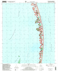
1998 Map of North Islands
USGS Topo · Published 2001About this map
Breton National Wildlife Refuge encompasses the fragile, shifting crescent of the Chandeleur Islands in this late-20th-century topographic record. Located in St. Bernard Parish, this maritime landscape is defined by the transition from the relatively protected waters of Chandeleur Sound and Shoalwater Bay to the open Gulf of Mexico. The map details the intricate network of tidal flats, marsh, and sand spits that form these barrier islands, providing a baseline for studying coastal erosion and hurricane impacts on Louisiana's outer defenses. Unlike mainland maps, this sheet focuses entirely on the hydrographic and topographic relationship between the barrier chain and the deep Smack Channel, offering essential data for maritime historians and environmental researchers interested in the evolution of the Mississippi River delta's eastern perimeter.
Find a feature on this map
6 named features on this map. Tap any name to fly to it.
Don’t see what you’re looking for? This feature index may not catch every label — zoom into the map to look around manually.
Map Details
Editions of this 1998 North Islands Map
This is the sole edition of this map. No revisions or reprints were ever made.
Other maps of this area

1951 · North Islands
USGS Topo · 1:24,000

1951 · New Harbor Islands
USGS Topo · 1:24,000
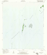
1951 · Freemason Island
USGS Topo · 1:24,000

1951 · Chandeleur Light
USGS Topo · 1:24,000

1953 · Mobile
USGS Topo · 1:250,000

1957 · Mobile
USGS Topo · 1:250,000

1957 · Breton Sound
USGS Topo · 1:250,000

1960 · Mobile
USGS Topo · 1:250,000

1961 · Breton Sound
USGS Topo · 1:250,000

1963 · Mobile
USGS Topo · 1:250,000