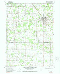
1959 Map of North Judson
USGS Topo · Published 1989About this map
North Judson serves as a major railroad crossroads in the late 1950s, where several lines converge in the northern portion of the landscape. The Chesapeake and Ohio, Erie R R, and New York Central Railroad intersect here, shaping the town's industrial layout. This rail density is contrasted by the surrounding agricultural flats of Wayne and Richgrove townships. The land is defined by an extensive reclamation network, including the Blue Sea Ditch, Sharp Ditch, and Keller Arm, reflecting a massive engineering effort to drain the marshy terrain for farming.
Find a feature on this map
41 named features on this map. Tap any name to fly to it.
Don’t see what you’re looking for? This feature index may not catch every label — zoom into the map to look around manually.
Map Details
Editions of this 1959 North Judson Map
2 editions found
Other maps of this area

1953 · Chicago
USGS Topo · 1:250,000

1957 · Chicago
USGS Topo · 1:250,000

1957 · Knox West
USGS Topo · 1:24,000

1958 · La Crosse
USGS Topo · 1:24,000

1959 · English Lake
USGS Topo · 1:24,000

1959 · North Judson
USGS Topo · 1:24,000

1959 · San Pierre
USGS Topo · 1:24,000

1962 · Medaryville
USGS Topo · 1:24,000

1962 · Denham
USGS Topo · 1:24,000
1962 · Ripley
USGS Topo · 1:24,000