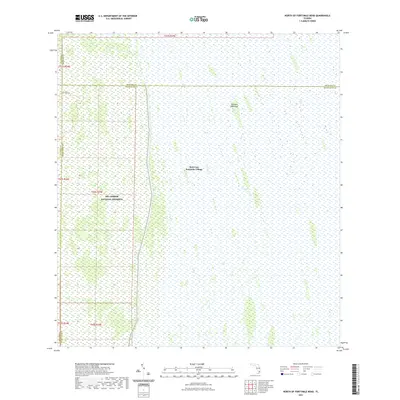
2021 Map of North of Fortymile Bend
USGS Topo · Published 2021About this map
Mart Law Seminole Village stands as a focal point of indigenous residency within this 2021 modern survey of the South Florida interior. This landscape is defined by the convergence of the Big Cypress National Preserve and the expansive wetlands of The Everglades. The map illustrates the complex hydrology and distinct landforms characteristic of the region, such as Choctaw Hammock, which rise above the surrounding marshes. The presence of the Jet Port Trl in the northwestern corner suggests the historical attempts at infrastructure development within these protected environments. Spanning the intersection of Collier, Broward, and Miami-Dade counties, the sheet provides a detailed look at the township and range divisions that overlay this vast conservation area, showing how modern administrative boundaries interact with the natural ecosystems of the Florida peninsula.
Find a feature on this map
14 named features on this map. Tap any name to fly to it.
Don’t see what you’re looking for? This feature index may not catch every label — zoom into the map to look around manually.
Map Details
Editions of this 2021 North of Fortymile Bend Map
This is the sole edition of this map. No revisions or reprints were ever made.
Other maps of this area

1956 · Miami
USGS Topo · 1:250,000

1956 · West Palm Beach
USGS Topo · 1:250,000

1957 · West Palm Beach
USGS Topo · 1:250,000

1958 · West Palm Beach
USGS Topo · 1:250,000

1958 · Miami
USGS Topo · 1:250,000

1973 · Fortymile Bend
USGS Topo · 1:24,000

1973 · Custard Apple Hammock
USGS Topo · 1:24,000

1973 · Fiftymile Bend
USGS Topo · 1:24,000

1973 · North Of Fiftymile Bend
USGS Topo · 1:24,000

1973 · Long Island
USGS Topo · 1:24,000