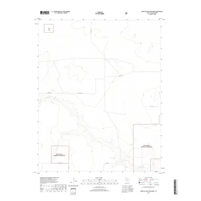
2019 Map of North of Red Cow Draw
USGS Topo · Published 2019About this map
Rita Blanca National Grassland dominates the southern reaches of this corner of Dallam County, reflecting the conservation of the shortgrass prairie after the Dust Bowl era. The landscape is defined by the winding course of Coldwater Cr, which cuts through the high plains to create distinct drainage patterns in an otherwise flat expanse. Transportation in the region relies on a sparse network of named tracks and lanes, such as Ben Tom Rd and Minnie Mack Ln, which serve the agricultural and grazing operations typical of the Texas Panhandle. The placement of Lost Camp Rd and E High Lonesome Ln suggests the isolation of the rural homesteads and ranching outposts that occupy this northernmost tip of the state.
Find a feature on this map
9 named features on this map. Tap any name to fly to it.
Don’t see what you’re looking for? This feature index may not catch every label — zoom into the map to look around manually.
Map Details
Editions of this 2019 North of Red Cow Draw Map
This is the sole edition of this map. No revisions or reprints were ever made.
Other maps of this area
1954 · Dalhart
USGS Topo · 1:250,000
1958 · Dalhart
USGS Topo · 1:250,000
1962 · Dalhart
USGS Topo · 1:250,000
1964 · Stratford 2 SE
USGS Topo · 1:24,000
1964 · Stratford 2 NE
USGS Topo · 1:24,000
1969 · Boise City SE
USGS Topo · 1:24,000
1971 · Conrad SW
USGS Topo · 1:24,000
1971 · Conrad
USGS Topo · 1:24,000
1973 · Stratford 2 NW
USGS Topo · 1:24,000
1973 · Coldwater East
USGS Topo · 1:24,000