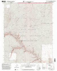
1998 Map of North of Red Cow Draw
USGS Topo · Published 2001About this map
Coldwater Creek carves a winding path through the High Plains landscape of the Texas Panhandle, defining the topography of this corner of Dallam County. The map reveals a specialized land management area where the Rita Blanca National Grassland spans the border between Texas and Oklahoma's Cimarron County. This late-twentieth-century survey documents a region defined more by its drainage patterns and resource infrastructure than by dense habitation. A single named settlement, Lost Camp, sits along the southern reaches of the creek, while a lone Drill Hole and a prominent Pipeline crossing the terrain signal the ongoing industrial presence of the energy sector in this open grassland environment.
Find a feature on this map
7 named features on this map. Tap any name to fly to it.
Don’t see what you’re looking for? This feature index may not catch every label — zoom into the map to look around manually.
Map Details
Editions of this 1998 North of Red Cow Draw Map
This is the sole edition of this map. No revisions or reprints were ever made.
Other maps of this area

1954 · Dalhart
USGS Topo · 1:250,000

1958 · Dalhart
USGS Topo · 1:250,000

1962 · Dalhart
USGS Topo · 1:250,000

1964 · Stratford 2 SE
USGS Topo · 1:24,000

1964 · Stratford 2 NE
USGS Topo · 1:24,000

1969 · Boise City SE
USGS Topo · 1:24,000

1971 · Conrad SW
USGS Topo · 1:24,000
1971 · Conrad
USGS Topo · 1:24,000

1973 · Stratford 2 NW
USGS Topo · 1:24,000

1973 · Coldwater East
USGS Topo · 1:24,000