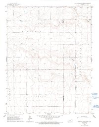
1966 Map of North of Shirley Creek
USGS Topo · Published 1993About this map
The high plains of western Kansas are defined by complex drainage systems across the Hamilton and Kearny county line in the mid-1960s. The landscape is marked by a series of significant draws, including James Draw, Mattox Draw, and Hibbard West Draw, which weave through the townships of Richland, Kendall, and Liberty. These topographic features indicate the importance of seasonal water flow in an otherwise arid region. Evidence of mid-century aviation appears with a small Landing Strip, reflecting the necessity of air travel for remote agricultural communities. This detailed record of land use also highlights an intricate network of fence and field lines, illustrating the established boundaries of rural land ownership and farming practices at the time of the field check in 1966.
Find a feature on this map
8 named features on this map. Tap any name to fly to it.
Don’t see what you’re looking for? This feature index may not catch every label — zoom into the map to look around manually.
Map Details
Editions of this 1966 North of Shirley Creek Map
2 editions found
Other maps of this area

1955 · Scott City
USGS Topo · 1:250,000

1958 · Scott City
USGS Topo · 1:250,000

1965 · Leoti 3 NW
USGS Topo · 1:24,000

1966 · Tribune 4 NW
USGS Topo · 1:24,000
1966 · Leoti 3 SW
USGS Topo · 1:24,000
1966 · Tribune 4 SE
USGS Topo · 1:24,000

1966 · Tribune 4 NE
USGS Topo · 1:24,000
1966 · Tribune 4 SW
USGS Topo · 1:24,000

1970 · Selkirk SW
USGS Topo · 1:24,000

1970 · Selkirk SE
USGS Topo · 1:24,000