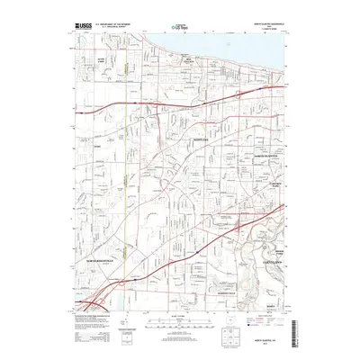
2013 Map of North Olmsted
USGS Topo · Published 2013About this map
Bay Village and Westlake define this suburban landscape west of the West Branch Rocky River, where residential expansion meets the remaining natural corridors of the Lake Erie shoreline. This modern survey illustrates the dense network of roadways like Hilliard Blvd and Lorain Rd that connect North Olmsted to the regional core of Cleveland. The area's long-established community history is anchored by numerous burial grounds, including the Butternut Ridge Cem and the expansive Sunset Memorial Park Cem. Notable transportation and entertainment landmarks are still present, such as the Aut-O-Rama Twin Drive-In Theatre and the R & M Aviation Airport, reflecting the mid-century development patterns that shaped these Cuyahoga and Lorain County suburbs. Public spaces like Cleveland Metro Park follow the winding river valley, preserving green space amidst the grid.
Find a feature on this map
61 named features on this map. Tap any name to fly to it.
Don’t see what you’re looking for? This feature index may not catch every label — zoom into the map to look around manually.
Map Details
Editions of this 2013 North Olmsted Map
This is the sole edition of this map. No revisions or reprints were ever made.
Other maps of this area

1901 · Oberlin
USGS Topo · 1:62,500

1902 · Berea
USGS Topo · 1:62,500

1903 · Oberlin
USGS Topo · 1:62,500

1904 · Berea
USGS Topo · 1:62,500

1950 · Cleveland
USGS Topo · 1:250,000

1953 · West View
USGS Topo · 1:24,000

1953 · Berea
USGS Topo · 1:24,000

1953 · Grafton
USGS Topo · 1:24,000

1953 · Avon
USGS Topo · 1:24,000
1953 · Lakewood
USGS Topo · 1:24,000