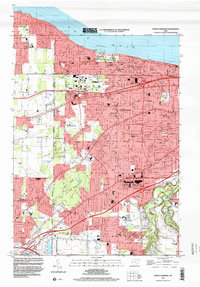
1994 Map of North Olmsted
USGS Topo · Published 2000About this map
Lake Erie defines the northern boundary of this suburban landscape, where the communities of Avon Lake, Bay Village, and Westlake have matured into a dense network of residential streets and community landmarks. The terrain is notably marked by Butternut Ridge, a geological remnant of an ancient shoreline that now serves as a primary corridor for settlement and transit. This 1994 snapshot of the western suburbs of Cleveland shows the area's transition into a fully developed residential region, yet it maintains significant green space through the Rocky River Metropolitan Reservation and numerous private grounds like the Avon Oaks Country Club. Family history is well-preserved across the quadrangle in various burial grounds, ranging from the Evergreen Cem near the lake to the Butternut Ridge Cem and Chestnut Grove Cem further south. The map documents a high density of parochial and public education centers, including Learwood Jr High Sch and St Bernadette Sch, illustrating the mid-to-late 20th-century growth of these Cuyahoga County communities.
Find a feature on this map
83 named features on this map. Tap any name to fly to it.
Don’t see what you’re looking for? This feature index may not catch every label — zoom into the map to look around manually.
Map Details
Editions of this 1994 North Olmsted Map
This is the sole edition of this map. No revisions or reprints were ever made.
Other maps of this area

1901 · Oberlin
USGS Topo · 1:62,500

1902 · Berea
USGS Topo · 1:62,500

1903 · Oberlin
USGS Topo · 1:62,500

1904 · Berea
USGS Topo · 1:62,500

1950 · Cleveland
USGS Topo · 1:250,000

1953 · West View
USGS Topo · 1:24,000

1953 · Berea
USGS Topo · 1:24,000

1953 · Grafton
USGS Topo · 1:24,000

1953 · Avon
USGS Topo · 1:24,000
1953 · Lakewood
USGS Topo · 1:24,000