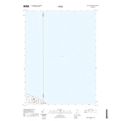
2019 Map of North Olmsted OE N
USGS Topo · Published 2019About this map
Lake Erie dominates this coastal survey, where the residential grids of Northeast Ohio meet the shoreline in the late 2010s. The map focuses on the established lakefront communities of Avon Lake and Bay Village, separated by the Lorain and Cuyahoga county line. The landscape is defined by its transit corridors, particularly Lake Rd and Electric Blvd, which run parallel to the coast. These thoroughfares serve as the primary arteries for a dense network of suburban streets, including Lear Nagle Rd and Bayview Dr. This map illustrates the modern extent of residential development along the lakefront, showing how these former resort and cottage areas have transitioned into permanent residential suburbs with a highly structured grid of residential drives and avenues.
Find a feature on this map
20 named features on this map. Tap any name to fly to it.
Don’t see what you’re looking for? This feature index may not catch every label — zoom into the map to look around manually.
Map Details
Editions of this 2019 North Olmsted OE N Map
This is the sole edition of this map. No revisions or reprints were ever made.
Other maps of this area

1901 · Oberlin
USGS Topo · 1:62,500

1902 · Berea
USGS Topo · 1:62,500

1903 · Oberlin
USGS Topo · 1:62,500

1904 · Berea
USGS Topo · 1:62,500

1950 · Cleveland
USGS Topo · 1:250,000

1953 · Avon
USGS Topo · 1:24,000
1953 · Lakewood
USGS Topo · 1:24,000
1953 · North Olmsted
USGS Topo · 1:24,000

1956 · Cleveland
USGS Topo · 1:250,000

1956 · Toledo
USGS Topo · 1:250,000