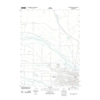
2011 Map of North Platte West
USGS Topo · Published 2011About this map
The confluence of the North Platte River and the South Platte River dominates this landscape, illustrating the intricate hydraulic engineering required for Nebraska agriculture. The North Platte Canal and Birdwood Canal cut across the terrain, feeding a network of ditches and reservoirs like Hansen Reservoir behind Hansen Dam. These waterways frame the westward expansion of North Platte, where residential grids meet the historical legacy of the Great Plains. Cultural landmarks are prominent near the riverbanks, including the Lincoln County Fairgrounds and the Buffalo Bill Wild West Rodeo Arena, reflecting the region's deep connection to equestrian and pioneer heritage. Further south, the community of Village Square and the North Platte Post Office anchor the urban center, while the North Platte Cemetery provides a primary point of interest for those researching local family history.
Find a feature on this map
57 named features on this map. Tap any name to fly to it.
Don’t see what you’re looking for? This feature index may not catch every label — zoom into the map to look around manually.
Map Details
Editions of this 2011 North Platte West Map
This is the sole edition of this map. No revisions or reprints were ever made.
Other maps of this area

1899 · North Platte
USGS Topo · 1:125,000

1902 · North Platte
USGS Topo · 1:125,000

1954 · North Platte
USGS Topo · 1:250,000

1956 · North Platte
USGS Topo · 1:250,000

1957 · North Platte
USGS Topo · 1:250,000

1967 · North Platte
USGS Topo · 1:250,000

1970 · North Platte East
USGS Topo · 1:24,000

1970 · North Platte West
USGS Topo · 1:24,000
1970 · North Platte SW
USGS Topo · 1:24,000
1970 · Hershey East
USGS Topo · 1:24,000
Featured Places
- North Platte, NE
- Green Acres Trailer Court, NE
- Key Estates, North Platte
- Mobile Manor, North Platte
- Village Square, North Platte