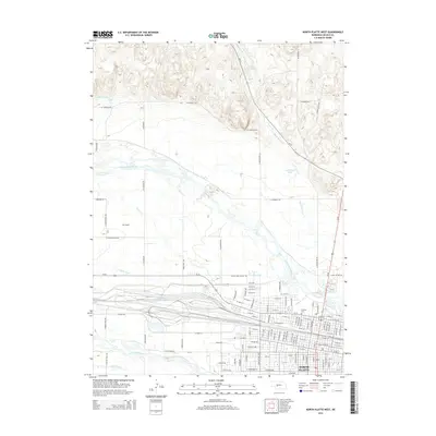
2014 Map of North Platte West
USGS Topo · Published 2014About this map
North Platte serves as the focal point of this 2014 survey, where the convergence of the North Platte River and South Platte River dictates the local geography. This confluence, historically significant for western migration and transportation, is flanked by an intricate network of irrigation infrastructure including the Birdwood Canal, N Platte Canal, and several reservoirs. The landscape reflects a transition from the urban grid of the city to the more open, canal-irrigated valley floor and the elevated terrain of W Weaver Hts to the north.
Find a feature on this map
120 named features on this map. Tap any name to fly to it.
Don’t see what you’re looking for? This feature index may not catch every label — zoom into the map to look around manually.
Map Details
Editions of this 2014 North Platte West Map
This is the sole edition of this map. No revisions or reprints were ever made.
Other maps of this area

1899 · North Platte
USGS Topo · 1:125,000

1902 · North Platte
USGS Topo · 1:125,000

1954 · North Platte
USGS Topo · 1:250,000

1956 · North Platte
USGS Topo · 1:250,000

1957 · North Platte
USGS Topo · 1:250,000

1967 · North Platte
USGS Topo · 1:250,000

1970 · North Platte East
USGS Topo · 1:24,000

1970 · North Platte West
USGS Topo · 1:24,000
1970 · North Platte SW
USGS Topo · 1:24,000
1970 · Hershey East
USGS Topo · 1:24,000
Featured Places
- North Platte, NE
- Green Acres Trailer Court, NE
- Key Estates, North Platte
- Mobile Manor, North Platte
- Village Square, North Platte