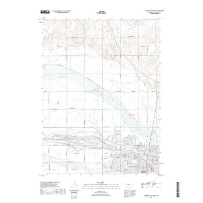
2017 Map of North Platte West
USGS Topo · Published 2017About this map
North Platte sits at the vital confluence of the North Platte River and the South Platte River, a landscape shaped by both hydrology and heavy industry. The massive rail yard of the Union Pacific dominates the southern portion of the quadrangle, illustrating the city's role as a primary transportation hub. Irrigation and water management systems, including the N Platte Canal and Birdwood Canal, stretch across the terrain, supporting the agricultural needs of the Nebraska plains. To the north, the terrain transitions into the more varied topography of the hills, where the Hansen Reservoir and White Horse Cr provide drainage toward the valley. Local history is anchored by the North Platte Cem and landmarks such as Scouts Rest Ranch Rd, which points to the area's heritage as a frontier crossroads. The dense grid of North Platte's western residential streets contrasts sharply with the open spaces of Orr Field and the riparian wetlands of Beer Slough.
Find a feature on this map
101 named features on this map. Tap any name to fly to it.
Don’t see what you’re looking for? This feature index may not catch every label — zoom into the map to look around manually.
Map Details
Editions of this 2017 North Platte West Map
This is the sole edition of this map. No revisions or reprints were ever made.
Other maps of this area

1899 · North Platte
USGS Topo · 1:125,000

1902 · North Platte
USGS Topo · 1:125,000

1954 · North Platte
USGS Topo · 1:250,000

1956 · North Platte
USGS Topo · 1:250,000

1957 · North Platte
USGS Topo · 1:250,000

1967 · North Platte
USGS Topo · 1:250,000

1970 · North Platte East
USGS Topo · 1:24,000

1970 · North Platte West
USGS Topo · 1:24,000
1970 · North Platte SW
USGS Topo · 1:24,000
1970 · Hershey East
USGS Topo · 1:24,000
Featured Places
- North Platte, NE
- Green Acres Trailer Court, NE
- Key Estates, North Platte
- Mobile Manor, North Platte
- Village Square, North Platte