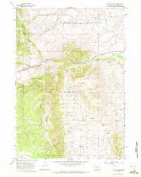
1967 Map of North Ridge
USGS Topo · Published 1972About this map
Bighorn National Forest dominates this landscape in northern Johnson County, where the transition from high mountain peaks to the western plains is marked by a complex system of early irrigation infrastructure. The map reveals an intricate network of water management features, including the Penrose Ditch, Brown and Foster Ditch, and the Moeller Ditch, which redirect snowmelt from high-altitude sources like French Creek and Clear Creek. These waterworks supported the agricultural development of the region below the North Ridge.
Find a feature on this map
37 named features on this map. Tap any name to fly to it.
Don’t see what you’re looking for? This feature index may not catch every label — zoom into the map to look around manually.
Map Details
Editions of this 1967 North Ridge Map
This is the sole edition of this map. No revisions or reprints were ever made.
Other maps of this area

1900 · Fort McKinney
USGS Topo · 1:125,000

1903 · Fort McKinney
USGS Topo · 1:125,000

1955 · Sheridan
USGS Topo · 1:250,000

1958 · Sheridan
USGS Topo · 1:250,000

1962 · Sheridan
USGS Topo · 1:250,000

1967 · Lake De Smet West
USGS Topo · 1:24,000

1967 · Caribou Creek
USGS Topo · 1:24,000
1967 · Klondike Ranch
USGS Topo · 1:24,000
1967 · Hunter Mesa
USGS Topo · 1:24,000
1967 · Stone Mountain
USGS Topo · 1:24,000