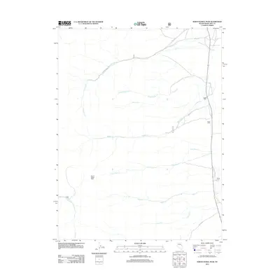
2012 Map of North Schell Peak
USGS Topo · Published 2012About this map
North Schell Peak anchors this high-elevation landscape in the Schell Creek Range of eastern Nevada. The terrain is defined by a series of drainage networks flowing eastward toward the valley floor, including Piermont Cr, Bassett Cr, and Little Negro Cr. These seasonal and perennial waterways historically supported small-scale ranching operations along the mountain fringe, visible here through established sites like Bassett Ranch, Keegan Ranch, and Home Ranch. A network of Forest Service roads, such as NFD 432 RD and NFD 387 RD, provides access across the shifting elevations and through the various canyons. This 2012 survey illustrates the enduring rural character of White Pine County, where water sources like Odgers Cr and Gordon Cr remain the primary drivers of land use and settlement placement in an otherwise arid environment.
Find a feature on this map
16 named features on this map. Tap any name to fly to it.
Don’t see what you’re looking for? This feature index may not catch every label — zoom into the map to look around manually.
Map Details
Editions of this 2012 North Schell Peak Map
This is the sole edition of this map. No revisions or reprints were ever made.
Other maps of this area
1952 · Ely
USGS Topo · 1:125,000

1956 · Ely
USGS Topo · 1:250,000

1959 · Ely
USGS Topo · 1:250,000
1959 · Schell Peaks
USGS Topo · 1:62,500

1963 · Ely
USGS Topo · 1:250,000
1981 · North Schell Peak
USGS Topo · 1:24,000
1981 · Duck Creek Valley
USGS Topo · 1:24,000
1981 · South Schell Peak
USGS Topo · 1:24,000
1981 · Cleve Creek Baldy
USGS Topo · 1:24,000
1982 · Kalamazoo Creek
USGS Topo · 1:24,000