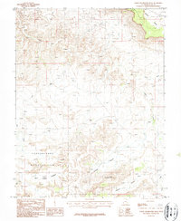
1987 Map of North Six-shooter Peak
USGS Topo · Published 1987About this map
Canyonlands National Park dominates the southern landscape of this 1987 provisional survey, revealing a complex topography of deep canyons and prominent mesas in San Juan County. The terrain is defined by dramatic elevations, most notably the spire of North Six-shooter Peak rising above the surrounding flats. Waterways like Indian Creek, Salt Creek, and Harts Draw have carved the earth into distinct geological features, including the sheltered basins of Corral Pocket, Bogus Pocket, and the simply named Pocket. While the area is largely characterized by its natural formations, such as a Natural Bridge, a lone Prospect label indicates small-scale exploration into the mineral potential of these high plateaus. This map captures the region after its 1960s designation as a national park, showing the limited unimproved roads and trails that provided access to the remote Hatch Point area.
Find a feature on this map
13 named features on this map. Tap any name to fly to it.
Don’t see what you’re looking for? This feature index may not catch every label — zoom into the map to look around manually.
Map Details
Editions of this 1987 North Six-shooter Peak Map
This is the sole edition of this map. No revisions or reprints were ever made.
Other maps of this area

1885 · La Sal
USGS Topo · 1:250,000

1951 · Upheaval Dome
USGS Topo · 1:62,500

1952 · Carlisle 2 SE
USGS Topo · 1:24,000

1953 · The Needles
USGS Topo · 1:62,500

1954 · Carlisle 4 SW
USGS Topo · 1:24,000

1954 · Carlisle 4 NW
USGS Topo · 1:24,000
1954 · Carlisle 4 SE
USGS Topo · 1:24,000

1954 · Carlisle 1 SE
USGS Topo · 1:24,000

1954 · Carlisle 4 NE
USGS Topo · 1:24,000

1954 · Carlisle 1 SW
USGS Topo · 1:24,000