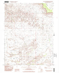
1997 Map of North Six-shooter Peak
USGS Topo · Published 2002About this map
Canyonlands National Park dominates the southwestern portion of this topographic survey, revealing the intricate network of drainage and elevation that defines this part of San Juan County. The terrain is characterized by massive plateaus like Hatch Point and distinct erosional features such as North Six-shooter Peak. Waterways like Indian Creek and Salt Creek have carved deep into the landscape, creating secluded basins known locally as pockets, including Salt Creek Pocket, Corral Pocket, and Bogus Pocket. These features suggest a history of cattle ranching and seasonal grazing in an area where natural barriers provided literal pockets for containment. A Natural Bridge and the winding course of Harts Draw further illustrate the geomorphology of the high desert plateau during the late twentieth century.
Find a feature on this map
11 named features on this map. Tap any name to fly to it.
Don’t see what you’re looking for? This feature index may not catch every label — zoom into the map to look around manually.
Map Details
Editions of this 1997 North Six-shooter Peak Map
This is the sole edition of this map. No revisions or reprints were ever made.
Other maps of this area

1885 · La Sal
USGS Topo · 1:250,000

1951 · Upheaval Dome
USGS Topo · 1:62,500

1952 · Carlisle 2 SE
USGS Topo · 1:24,000

1953 · The Needles
USGS Topo · 1:62,500

1954 · Carlisle 4 SW
USGS Topo · 1:24,000

1954 · Carlisle 4 NW
USGS Topo · 1:24,000
1954 · Carlisle 4 SE
USGS Topo · 1:24,000

1954 · Carlisle 1 SE
USGS Topo · 1:24,000

1954 · Carlisle 4 NE
USGS Topo · 1:24,000

1954 · Carlisle 1 SW
USGS Topo · 1:24,000