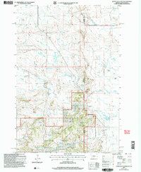
2005 Map of North Slick Creek
USGS Topo · Published 2007About this map
Custer National Forest spans the southwestern portion of this map, marked by a network of water resources and ranching infrastructure. The landscape is defined by the headwaters of the Slick Creek drainage system, including North Slick Creek, Middle Slick Creek, and South Slick Creek. Water management is central to the area's utility, evidenced by features such as Plum Creek Reservoir, Section 21 Reservoir, and various springs like Brown Jug Spring and Bill Spring.
Find a feature on this map
23 named features on this map. Tap any name to fly to it.
Don’t see what you’re looking for? This feature index may not catch every label — zoom into the map to look around manually.
Map Details
Editions of this 2005 North Slick Creek Map
This is the sole edition of this map. No revisions or reprints were ever made.
Other maps of this area

1935 · Buffalo
USGS Topo · 1:125,000

1954 · Lemmon
USGS Topo · 1:250,000

1954 · Ekalaka
USGS Topo · 1:250,000

1956 · Ekalaka
USGS Topo · 1:250,000

1957 · Lemmon
USGS Topo · 1:250,000

1958 · Ekalaka
USGS Topo · 1:250,000

1965 · Ekalaka
USGS Topo · 1:250,000

1974 · Caroline Butte
USGS Topo · 1:24,000
1977 · Scott Creek
USGS Topo · 1:24,000
1977 · Camp Crook
USGS Topo · 1:24,000