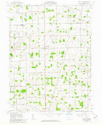
1961 Map of North Star
USGS Topo · Published 1963About this map
The Greenville Treaty Line cuts across the rural landscape of Darke and Mercer counties, serving as a historic divider between different land survey systems. North of this line, the terrain is organized by the First Principal Meridian within the Congress Lands, while the area to the south follows the Great Miami River Base. The village of North Star stands as a central hub at this intersection of geography and history, surrounded by a dense network of country roads named for local families such as Dirksen Road, Mangen Road, and Huwer Rd.
Find a feature on this map
88 named features on this map. Tap any name to fly to it.
Don’t see what you’re looking for? This feature index may not catch every label — zoom into the map to look around manually.
Map Details
Editions of this 1961 North Star Map
2 editions found
Other maps of this area

1908 · St. Henry
USGS Topo · 1:62,500

1909 · Loramie
USGS Topo · 1:62,500

1911 · Loramie
USGS Topo · 1:62,500

1911 · Covington
USGS Topo · 1:62,500

1944 · Covington
USGS Topo · 1:62,500

1944 · Loramie
USGS Topo · 1:62,500

1953 · Muncie
USGS Topo · 1:250,000

1956 · Muncie
USGS Topo · 1:250,000

1961 · Dawn
USGS Topo · 1:24,000
1961 · Rossburg
USGS Topo · 1:24,000