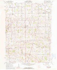
1961 Map of North Star
USGS Topo · Published 1990About this map
The Wabash River meanders across the rural landscape of Darke and Mercer counties, anchoring a network of small agricultural settlements at the start of the 1960s. The village of North Star serves as a central hub, surrounded by smaller communities like Yorkshire to the east and Brock to the south. The land is defined by a dense grid of township roads named for local families, including Rindler Road, Goettemoeller Road, and Honsapple Road, reflecting a deeply rooted farming heritage.
Find a feature on this map
87 named features on this map. Tap any name to fly to it.
Don’t see what you’re looking for? This feature index may not catch every label — zoom into the map to look around manually.
Map Details
Editions of this 1961 North Star Map
2 editions found
Other maps of this area

1908 · St. Henry
USGS Topo · 1:62,500

1909 · Loramie
USGS Topo · 1:62,500

1911 · Loramie
USGS Topo · 1:62,500

1911 · Covington
USGS Topo · 1:62,500

1944 · Covington
USGS Topo · 1:62,500

1944 · Loramie
USGS Topo · 1:62,500

1953 · Muncie
USGS Topo · 1:250,000

1956 · Muncie
USGS Topo · 1:250,000

1961 · Dawn
USGS Topo · 1:24,000
1961 · Rossburg
USGS Topo · 1:24,000