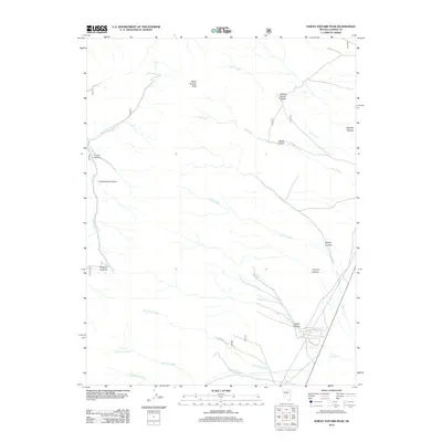
2012 Map of North Toiyabe Peak
USGS Topo · Published 2012About this map
North Toiyabe Peak anchors this high-elevation landscape in Lander County, defining a region where water and relief dictate the human footprint. The terrain is deeply incised by drainages such as Cahills Cañon, Spanish Canyon, and Cottonwood Canyon, which funnel seasonal runoff toward the desert basins. While the higher elevations are marked by landmarks like Kingston Summit, the lower reaches show signs of modern access and settlement near Gillman Spring. The presence of residential street names such as Gillman Springs Ct and Gillman Cir indicates late-twentieth-century development at the canyon mouths, where perennial flows from Frenchman Creek and Santa Fe Creek have historically drawn travelers and ranchers. This 2012 survey captures the intersection of traditional Great Basin land use and contemporary residential expansion in the shadow of the peaks.
Find a feature on this map
22 named features on this map. Tap any name to fly to it.
Don’t see what you’re looking for? This feature index may not catch every label — zoom into the map to look around manually.
Map Details
Editions of this 2012 North Toiyabe Peak Map
This is the sole edition of this map. No revisions or reprints were ever made.
Other maps of this area
1926 · Roberts Mountains
USGS Topo · 1:250,000
1929 · Roberts Mountains
USGS Topo · 1:250,000

1955 · Millett
USGS Topo · 1:250,000
1956 · Millett Ranch
USGS Topo · 1:62,500
1956 · Austin
USGS Topo · 1:62,500

1959 · Millett
USGS Topo · 1:250,000
1960 · Spencer Hot Springs
USGS Topo · 1:62,500
1960 · Wildcat Peak
USGS Topo · 1:62,500
1978 · Summit Mountain
USGS Topo · 1:100,000
1985 · Smith Creek Valley
USGS Topo · 1:100,000