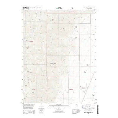
2015 Map of North Toiyabe Peak
USGS Topo · Published 2015About this map
North Toiyabe Peak and Bunker Hill dominate this high-altitude landscape within the Toiyabe National Forest, where the terrain drops sharply eastward into the Big Smoky Valley. This 2015 survey reveals a complex drainage network defined by deep incisions like Kingston Canyon and Big Creek Canyon, illustrating the Great Basin's characteristic basin-and-range topography. The presence of Sawmill Canyon and Santa Fe Canyon suggests a history of local resource extraction and early mountain passage. Water sources are critical in this arid environment, marked by Gillman Spring and perennial flows such as Rock Cr and Frenchman Cr. The map provides a precise look at the rugged access points used by researchers and outdoorsmen, including Gillman Springs Ct and routes through Corral Canyon and Cottonwood Canyon.
Find a feature on this map
36 named features on this map. Tap any name to fly to it.
Don’t see what you’re looking for? This feature index may not catch every label — zoom into the map to look around manually.
Map Details
Editions of this 2015 North Toiyabe Peak Map
This is the sole edition of this map. No revisions or reprints were ever made.
Other maps of this area
1926 · Roberts Mountains
USGS Topo · 1:250,000
1929 · Roberts Mountains
USGS Topo · 1:250,000

1955 · Millett
USGS Topo · 1:250,000
1956 · Millett Ranch
USGS Topo · 1:62,500
1956 · Austin
USGS Topo · 1:62,500

1959 · Millett
USGS Topo · 1:250,000
1960 · Spencer Hot Springs
USGS Topo · 1:62,500
1960 · Wildcat Peak
USGS Topo · 1:62,500
1978 · Summit Mountain
USGS Topo · 1:100,000
1985 · Smith Creek Valley
USGS Topo · 1:100,000