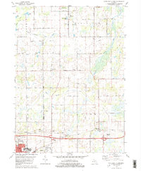
1981 Map of Northeast Albion
USGS Topo · Published 1981About this map
The village of Springport and the surrounding rural landscapes of Jackson and Calhoun counties are meticulously documented in this early 1980s record. This region is characterized by the intricate drainage of the North Branch Rice Creek and South Branch Rice Creek, punctuated by distinctive water bodies such as White Lake, Clark Lake, and the curiously named Lakes of the Gang. For genealogists and local historians, the map serves as an excellent guide to small settlements like Devereaux and Quakertown, alongside established burial grounds including Quakertown Cem and Perry-Graham Cem. The southern edge reveals the industrial and transportation hub of Albion, where the Conrail lines intersect the city's grid near the Armory and local High Sch. This survey also preserves the locations of mid-century cultural markers, including a Drive-in Theater and the Riske Landing Strip.
Find a feature on this map
61 named features on this map. Tap any name to fly to it.
Don’t see what you’re looking for? This feature index may not catch every label — zoom into the map to look around manually.
Map Details
Editions of this 1981 Northeast Albion Map
2 editions found
Other maps of this area

1919 · Springport
USGS Topo · 1:62,500

1921 · Springport
USGS Topo · 1:62,500

1921 · Marshall
USGS Topo · 1:62,500

1923 · Marshall
USGS Topo · 1:62,500

1943 · Marshall
USGS Topo · 1:62,500

1948 · Spring Arbor
USGS Topo · 1:62,500

1948 · Homer
USGS Topo · 1:62,500

1949 · Homer
USGS Topo · 1:62,500

1949 · Spring Arbor
USGS Topo · 1:62,500

1958 · Grand Rapids
USGS Topo · 1:250,000