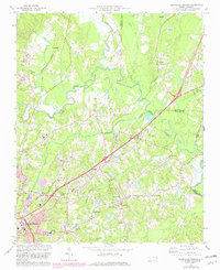
1973 Map of Northeast Durham
USGS Topo · Published 1982About this map
The confluence of the Little River, Flat River, and Eno River forms the Neuse River at the heart of this landscape, a critical hydrological junction northeast of Durham. During the early 1970s, the area maintained a mix of rural community centers and emerging suburban infrastructure. Small settlements such as Gorman, Fairntosh, and Cozart are interspersed with several local institutions, including Council-Christian Academy and the Merrick-Moore Sch.
Find a feature on this map
47 named features on this map. Tap any name to fly to it.
Don’t see what you’re looking for? This feature index may not catch every label — zoom into the map to look around manually.
Map Details
Editions of this 1973 Northeast Durham Map
4 editions found
Other maps of this area

1943 · Durham South
USGS Topo · 1:62,500

1943 · Raleigh
USGS Topo · 1:62,500

1943 · Creedmoor
USGS Topo · 1:62,500

1944 · Creedmoor
USGS Topo · 1:62,500

1951 · Raleigh
USGS Topo · 1:62,500

1951 · Durham South
USGS Topo · 1:62,500

1951 · Durham North
USGS Topo · 1:62,500

1953 · Raleigh
USGS Topo · 1:250,000

1953 · Greensboro
USGS Topo · 1:250,000

1954 · Greensboro
USGS Topo · 1:250,000